A Brief History of Bramfield
Introduction
June Brereton, a local historian has compiled this short history of Bramfield to give a picture of the foundation of the Bramfield we see today and to encourage interested people to look further with the help of a few notes on source material.
The more you delve into historical research you realise that putting onto the printed page, definite facts about anything, can be very daunting. Someone will always be able to come after you and question something, or an interesting piece of information will come to hand and a book may never justify a second printing. The computer has changed all that and facts on-line can always be up-dated as time goes by.
Bramfield – (variously, Bufeld, Brunfeld, Bramfeld, Bromfeld etc.) is a name derived from a clearing in broom (brushwood) or an area free from forest. This could possibly be an early Anglo-Saxon name but as yet no evidence has been found of a settlement before the 11th century.
Bramfield lies inland on the edge of the Sandlings area of East Suffolk in an area of gravelly sands, topped by clay with gently sloping stream valleys which are part of the Blyth River system. This landscape was fashioned by the succeeding ice ages and the only stone found locally is that left behind as glacial erratics and flints. This has a bearing on the history and appearance of the present day village.

Map of Historic Buildings in Bramfield
The Bramfield Oak
The legend of the Bramfield Oak came about through the existence of the Bungay Ballad detailing the flight of Hugh Bigod from the men of Henry II (12th century) to his castle in Bungay. There was an old oak in Bramfield Hall Park it became known as "The Bramfield Oak" due to the following in the 5th stanza of the ballad to be found in full in The Suffolk Garland.
When the Baily had ridden to Bramfield oak,
Sir Hugh was at Ilksall bower;
When the Baily had ridden to Halesworth cross,
He was singing in Bungay tower-
"Now that I’m in my castle of Bungay,
Upon the river of Waveney,
I will ne care for the King of Cockney."
Miles Gladwyn who researched the provenance of the ballad agrees with me that the oak in the grounds of Bramfield Hall is unlikely to be the one of the 12th century as it was only some 3-400 years old and that it is more likely that Hugh Bigod, earl of Norfolk used the route of the Earlsway mentioned in the 15th century manorial extent. It is also a way to Halesworth and passes not far from a Parish boundary marker – oak on O.S. maps even today though there is no sign of it now.
— June Brereton
Early Times
Recently a portion of a stone age axe was found on Brook Hall land and there is evidence of Bronze Age people with a hoard of bronze axes found about a mile south of the village just about where the old road joins the A144 and another lone specimen discovered on the edge of the parish, showing that the area was suitable for transient settlement.
Another find recorded by Suckling, writing in 1848, describes "about five or six years since, twelve large celts were discovered, not far from this spot (ie. the ‘castle’) lying in a circle, within which were eight smaller ones. They laid very near the surface of the earth, and were turned up by a plough". This was recorded as being on Reginald Rabett’s land and most probably is the same hoard poorly noted down.
So suitable was the land that the clearance of the ancient woodland provided excellent
farmland that has been intensively worked for 2000 years leaving little trace of a succession of
settlers. Nothing is seen of the Iron Age and only sketchy remains of two Romano-British sites,
situated to the north and south of the present village. The one to the north may produce
further evidence when more field walking is possible in the autumn of 2008.
This brings us to the Anglo Saxon/Danish period when we begin to see the Bramfield we know
today.
 Roads
Roads
The axis of the village has changed from west/east to north/south. 15th century documents indicate that the more important route through the village had been the Bury St Edmund’s to Dunwich highway which is now Walpole Lane and carries on across the fields as a footpath to cross the A12 near The Little Chef café. The A144 did not exist until the development of the Turnpike in 1785 except as a fragmented road from Halesworth to Bramfield Green and thence off through Bramfield Hall Park to Sibton. The only access to the "A12" and thus Darsham, was a footpath. With the demise of Dunwich from the 14th century, and the development of Halesworth as a thriving market town, traffic was gradually growing and so the line of the present trunk road developed. Early settlements along the Dunwich ‘road’ behind Hall Wood were abandoned and the present settlement pattern nearer the church was established. The last of these early settlements was Potash Farm which disappeared in the 1960s.
Early Medieval
Immediately before the Norman Conquest there were probably around 200 people living in Bramfield. One can assume that they didn’t spring up over night and that a substantial settlement had been growing up through the preceding 200 years. At the time of the Conquest, the land (7 carucates, about 800 acres) was held as an estate by an Anglo Saxon Dane called Manni Swart. There was plenty of woodland for the grazing of pigs. Most importantly we know he had a church.
Because of the lack of building stone there is no evidence of these people until the church tower was built of flint/rubble in the 12th century.
Bramfield Castle - Administrative site of Manor
A medieval ringwork (no public access). National Grid Reference TM40297346.
National Monument Number 30525
| Some statistics. Diameter of ring: Area of: |
Approximately 83 metres. 0.4 hectares. |
Platform - raised about 0.6m above surrounding ground. Ditch - up to 7 metres in width.
Castle – where is the castle?
Although this earthwork has been labelled ‘Castle’ there was never a stone castle as in the popular idea of a castle. It is a medieval or possibly Saxon earthwork which may have had an
inner bank topped with a timber palisade encircling the enclosure.
There is no mention of the word ‘castle’ in any of the manorial documents and it does not
appear until 1745 on an estate map. The area from Hall Wood to the castle was wood or wood
pasture and may have obscured the feature.
The long causeway type earthwork (running north-westwards away from the ring) is the
remains of a boundary possibly forming the enclosed land of a bailey, an area for grazing.
Why is it here?
The position is a commanding one overlooking the important medieval Kings Highway from Bury St Edmund’s to Dunwich and the Sibton road which led from Yoxford. It may have been here in Manni Swart’s time or it could have been an illegal ‘castle’ built during the troubled times of a civil war in the 1140’s.
Who lived here?
Before 1066 the manor of Bramfield was in the hands of Manni Swart, an Anglo-Saxon Dane, a
thane i.e. a substantial landholder with duties in the king’s service, having a church, a kitchen,
a bell house and a fortified dwelling-place. After 1066 these holdings were ceded by the king to Alan, Count of Richmond and subsequently leased to a family who took the name de Bramfield The ringwork may have been the domestic site of the de Bramfield family. From a 15th century survey of Bramfield Manor it is possible to get a picture of the buildings that
might have been within the circle – a capital house or hall with chambers annexed, a dovecote,
stables and a grange round a courtyard. There was to be right of way to the Lord’s pound and
free access to the hall for the Lord to hold courts there as often as he needed.
Eudo de Bramfield certainly gave the church (ecclesium meum = my church) to Blythburgh Priory
before 1160 so it seems his family may have been living here.
So far only one piece of medieval pottery has been found in the ditch and as it is a scheduled monument it may be impossible to mount an archaeological dig.
Many of the cottages and farms documented in 1478/9 are still on the same site today though will have been rebuilt many times and may only contain small amounts of original fabric. The oldest and most prominent building in the village is:
St Andrew’s Church
 As already mentioned there was a church here before 1086, which was almost certainly timber framed. All other churches in the neighbourhood have remains of Norman architecture – a doorway, a window or archway and it is strange that Bramfield shows no sign of an update during that period. We
cannot detect any earlier style than Early English due to the complete rendering inside and out but one
need not rule out entirely that there was a flint and rubble built Norman church which was completely
replaced in the early 14th Century.
As already mentioned there was a church here before 1086, which was almost certainly timber framed. All other churches in the neighbourhood have remains of Norman architecture – a doorway, a window or archway and it is strange that Bramfield shows no sign of an update during that period. We
cannot detect any earlier style than Early English due to the complete rendering inside and out but one
need not rule out entirely that there was a flint and rubble built Norman church which was completely
replaced in the early 14th Century.
Outside
The most striking object in the churchyard is the detached tower. It has generally been held to be a Norman building but a recent theory is that it is more likely to be contemporary with the main church i.e. 14th century (Stephen Hart, architectural advisor to the Round Tower Churches Trust). There is certainly no architectural evidence of Norman style in the tower but it could have had an earlier existence as a manorial building of secure storage and as a bell tower. There would have had to be a manorial bell somewhere to bring people to mass and to control agricultural activities.
| Some statistics. Height: | 43’6" | |
| Wall: | 4’ 6" thick | |
| Bells: | Treble 4cwt 2qtrs | Both cast by William and Alice Brend |
| No 2 5cwt 2qtrs | of Norwich in 1621. | |
| No 3 7cwt | These three cast by William Chamberlain | |
| No 4 8cwt | of London in 1440. | |
| Tenor 12cwt | ||
The bells stand in a 17th century frame and were last overhauled in 1890. They are reasonably easy to ring but some main bearings are worn. There is wear where the clappers strike and two bells need quarter turning. There is also some movement in the frame.
The Church Itself
The main fabric is entirely 14th century, this building replacing the humble timber framed building mentioned in the Domesday Survey of 1086. The church belonged to the Lord of the Manor (the de Bramfield family) who gave it to Blythburgh Priory before 1160. The original church was almost certainly not attached to the tower as there are no signs of a gable fixing. The site of the present, most certainly enlarged church may be new, due to the sloping nature of the land and the proximity of the road. A drawing of 1847 by Rev Alfred Suckling shows two cottages on what is now churchyard bringing the road close by the tower. But I am inclined to think that the church has always been on the same site. Again there is no evidence of Norman architecture but that does not preclude the building of a Norman Church later eclipsed by the new Gothic style.
The building consists of a simple nave and chancel, entirely thatched, with a slightly damaged original cross on the west gable. The windows show decorated tracery in the chancel, the south side having interesting stops on the dripstones.
Inside the Church
The Nave
In common with most churches, the box pews, three decker pulpit and gallery inserted to accommodate the new
form of preaching worship in the 17th Century, were removed in the renovations of the 1860’s and 70’s. The font
was moved from a central position and probably re-cut. During the re-ordering a large floor slab with evidence of
a medieval brass long since removed and sold off in the 17th Century was repositioned just to the north of the
font.
We have little documentary evidence of the effect that the Reformation and its extension into the 17th Century had on Bramfield’s church but we do know that during the reign of Edward VI, because of the lessening of ceremony in church services excess silver plate was sold and the money used to buy two coffers and to mend the church inside and out. At the same time the side altars would have vanished and niches containing images would have been emptied but the rood screen with its Catholic iconography survived. The wall painting on the north wall may have been lime washed over but it is strange that so much of it remained in the 19th Century that the niche was covered with a linen cloth with religious texts on it. Other paintings noticed during repairs in the 19th century were re–lime–washed. The stone altar would have been replaced with a wooden table as can be seen at Blyford Church but presumably this went in the later changes made to the sanctuary in the 1870 reordering.
William Dowsing’s visit to Bramfield on April 9th 1644 is well recorded when his agents destroyed ‘24 superstitious pictures; one crucifix,and a picture of Christ; and 12 angells on the roof; and diver Jesus’s, in capital letters; and the steps to be levelled, by Sir Robert Brook‘ At this time the roof was not ’ceiled‘; this did not happen until the first half of the 19th century.
 Fortunately in all the iconoclasm, renewing and restoration, the gloriously carved, and gilded gesso
decorated 15th or early 16th century rood screen has been carefully preserved and the only new part is the
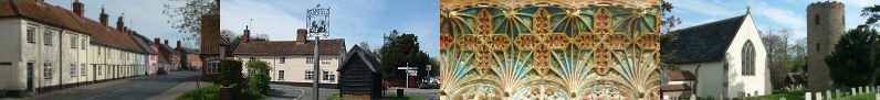
wooden canopy. The screen supports the rood loft, which was approached for tending candles etc. up a stone staircase in the thickened pillar immediately inside the chancel on the south side. The medieval paintings on the base of the screen are of Saints Mark and Matthew to the north and Saints Luke, John and Mary Magdalene on the south. There are
blank spaces to each end of the screen where medieval altars stood; one possibly for the religious gild of St Thomas for prayers for the departed and the other to Our Lady with a decorated piscina.
Fortunately in all the iconoclasm, renewing and restoration, the gloriously carved, and gilded gesso
decorated 15th or early 16th century rood screen has been carefully preserved and the only new part is the
wooden canopy. The screen supports the rood loft, which was approached for tending candles etc. up a stone staircase in the thickened pillar immediately inside the chancel on the south side. The medieval paintings on the base of the screen are of Saints Mark and Matthew to the north and Saints Luke, John and Mary Magdalene on the south. There are
blank spaces to each end of the screen where medieval altars stood; one possibly for the religious gild of St Thomas for prayers for the departed and the other to Our Lady with a decorated piscina.
The nave windows are worthy of note, each one representing a religious symbol. On the north wall the lily (symbol of Advent, the Virgin Mary and the Immaculate Conception) and the olive (the symbol of peace). The south wall has the passion flower (the 5 stamens represent the 5 stigmata) and the rose, symbolising the purity of the Virgin Mary (the rose without thorns). These windows have been likened to those in Dennington church by C Woolnough but seem much finer and more delicate. The stonework was thoroughly restored in the work in the 1870’s . We know the glazier but sadly not the designer, Although seeming to be of a later time, bills show the windows to have been installed in 1860 and the west window to match in 1876.
- The 18th century hatchments are for the Rabett family who lived at Bramfield Hall for over 400 years (‘rabbits’ in their arms). Boards carried in procession at the burial of the holder of the arms and then hung on the dead mans house).
- The banner over the vestry door is that of the 1st Lord Gladwyn, prominent 20th century diplomat, also of Bramfield.
- There is a delightful set of kneelers designed, constructed and worked in the village.
The Chancel
The chancel is predominately Victorian in character with choir stalls, raised steps to the altar and stained glass in
memory of the vicar and his wife who were responsible for the re–ordering in 1872. A Reredos installed by Miss
Tatlock in memory of her parents at the turn of the 20th century.
 The floor is paved with a very interesting set of ledger slabs to the memory of the Rabett and Nelson families.
The Rabetts, were an old Bramfield family but the Nelsons (as far as is known, no close relation to the Norfolk
Nelsons) apparently came here from London to escape the strongly Puritan atmosphere there. The probable
reason being that they were related to Nelsons in Kelsale. In fact Edward must have met and married Mary
Rabett in Kelsale in 1658 as her father, Lambert Rabett was living there in 1640.11 The earliest Nelson slab is that
of Edward, born May 1624, son of Matthew Nelson, citizen of London. He learnt from his parents to "serve with
his whole heart the Church of England and the cause of the King". He was an ensign in 1640 in a Royalist army at
the age of 16 and pursued a military career in support of the King until he left to take up public duties. I am not
clear about the house in which the Nelsons dwelt but it may have been Holly Tree Farm. This house is a
substantial timber framed property built in Elizabethan style with an attractive porch, or alternatively Westleys
Farm, which is near some land then owned by the family. The family were not wealthy but being lawyers were
people of influence and may have been important in the attitude of the parish towards continuing Puritan reforms.
The floor is paved with a very interesting set of ledger slabs to the memory of the Rabett and Nelson families.
The Rabetts, were an old Bramfield family but the Nelsons (as far as is known, no close relation to the Norfolk
Nelsons) apparently came here from London to escape the strongly Puritan atmosphere there. The probable
reason being that they were related to Nelsons in Kelsale. In fact Edward must have met and married Mary
Rabett in Kelsale in 1658 as her father, Lambert Rabett was living there in 1640.11 The earliest Nelson slab is that
of Edward, born May 1624, son of Matthew Nelson, citizen of London. He learnt from his parents to "serve with
his whole heart the Church of England and the cause of the King". He was an ensign in 1640 in a Royalist army at
the age of 16 and pursued a military career in support of the King until he left to take up public duties. I am not
clear about the house in which the Nelsons dwelt but it may have been Holly Tree Farm. This house is a
substantial timber framed property built in Elizabethan style with an attractive porch, or alternatively Westleys
Farm, which is near some land then owned by the family. The family were not wealthy but being lawyers were
people of influence and may have been important in the attitude of the parish towards continuing Puritan reforms.
The most famous of the Nelson slabs is that of Bridgett Applewhaite his grand–daughter.
Bridgett really deserves a story of her own. Her life illustrates the drawback of the restricted society in which she
lived with little chance to travel around the country to meet new people. The family were quite small time professional gentry, too notable to make an alliance with a local tradesman or farmer but not grand enough for marriage into county society. Her mother died when she was 16, just when she might expect to be launched into society and then in all probability was looked after along with her younger brother by a maiden aunt Bridgett Nelson who was continually ailing and who "though never married, she freely underwent the care of a wife & mother". In truth they were not a healthy family. Mary her mother died of an apoplectic fit, her brother died
aged 27 of a debilitating cough and wasting disease and Aunt Bridgett of dropsy. Bridgett herself died of an apoplectic
fit aged 44. These medical frailties are all recorded in the chancel.
For all I know she may have been a difficult, unattractive woman, but she is described as an heiress though I suspect not a great one. However, she did not get married until she was 34 and so well and truly, in those times, on the shelf. She married a local man the second son of Henry Applewhaite who was "Favourite and Bayliff to Henry Heveningham, Henry Heron and John Bence, and remains so to Alexander Bence and George Dashwood, all esquires, and successively owners of the Heveningham Hall Estate". Henry Applewhaite must have thought that Bridgett, in spite of her advanced age would be a suitable and advantageous match for his son, being descended from the Rabetts and so connect socially into the local squirearchy.
What the marriage can have been like defies imagination but graphic details of her suffering are depicted on her memorial. This was followed during her widowhood by a struggle with her late husband’s family over the assets that she took into the marriage.
Before I quote Bridgett’s epitaph in full it might be appropriate to remember that unless a husband left a will bequeathing his estate to his wife, it all went to his family. It wasn’t until 1882 that a married woman’s property was separated from the control of her husband.
Part of Arthur’s memorial–
His Eldest Brother For her
Own Paternal Estates in this Town, and Blyford".
Bridgett’s memorial–
and of her husband Arthur
Here lies the body of Bridgett Applewhaite
Once Bridgett Nelson
After the fatigues of a Married Life
Borne by her with Incredible Patience
for Four Years and three Quarters, bating three weeks;
And after the Enjoiment of the Glorious
Freedom,
Of an easy and Unblemish’t widowhood,
For four years and upwards
She Resolved to run the Risk of a Second Marriage
Bed
But Death forbad the Bannsand
having with an Apoplectick Dart
[The same Instrument, with which he had
Formerly
Dispatcht her Mother]
Toucht the most vital part of the Brain;
She must have fallen Directly to the Ground
[as one Thunder-strook]
If she had not been Catch’t and Supported
by her Intended Husband.
Of which invisible Bruise,
After a struggle for above Sixty Hours
With that grand enemy to Life,
(But the certain and Merciful Friend to Helpless Old Age)
In Terrible Convulsions Plaintive Groans, or
Stupefying Sleep
Without recovery of her Speech, or Senses
She dyed on the 12th day Sepr in ye year of our
Lord 1737
Of her own age 44.
 Sadly we do know who her ‘intended’ was, but what a sad and tragic story this is.
Her uncle, Edward Nelson who was a lawyer, may have been the author of the later memorials and was the last
of the Nelsons in Bramfield, dying in 1744. To the last he upheld the dignity of the family and made sure his own
epitaph did justice to the memory of the Nelsons by having it erected prior to his death in 1736.
Sadly we do know who her ‘intended’ was, but what a sad and tragic story this is.
Her uncle, Edward Nelson who was a lawyer, may have been the author of the later memorials and was the last
of the Nelsons in Bramfield, dying in 1744. To the last he upheld the dignity of the family and made sure his own
epitaph did justice to the memory of the Nelsons by having it erected prior to his death in 1736.
The other distinctive features of the chancel are the fine monuments on the north wall to Arthur and Elizabeth Coke. These are examples of the work of Nicholas Stone who had carried out work in Westminster Abbey. Arthur’s father was Edward Coke, at one time the Lord Chief Justice and Nicholas Stone executed a fine monument to him in Titteshall Church in Norfolk. Arthur and his wife lived for a short while at Brook Hall, she dying in childbirth in 1627 and he two years later. Of interest for further study is an extensive inventory made of all the contents of Brook Hall on Arthur’s death.
The church has moved from one benefice to another during recent years and is now in the Blyth Valley Team Ministry, one of eleven churches.
There is a good guide in the church, also a copy of the registers (transcribed) from 1539–1596 and 1693–1889. An embroidered map of the Parish hangs in the church.
The Old Vicarage
(east of the church on the A144 opposite Bramfield garage) was built in 1846 on the site of the original 15th Century timber-framed Vicarage House.
Bramfield Hall
Bramfield Hall was in the Rabett family from at least 1420 when it was a timber framed building probably not much more than a cottage. The Rabetts were an ancient family and had been influential traders in Dunwich until the demise of that town. A William Rabett appears as M.P. for Dunwich in 1467. The many ledger slabs in the chancel pay tribute to their long association with the village. After the Reformation (1542) when the manor was sold back into civilian hands, the Rabetts acquired much of the land and woodland, which enabled them to develop a small park. The house was enlarged into a small Tudor mansion and later given a Georgian front, which today looks out over the A144 to parkland, now separately owned. The last Rabett to own Bramfield Hall was the Reverend Reginald Rabett who had livings in Leicestershire and then Northamptonshire; he had no children and even more importantly, little money due to the agricultural depression of the mid 19th century. He died in 1860 and his wife Mary in 1875. The Estate was put into administration, being sold in 1899 by the mortgagers to the Ogivily family of Thorpness. Subsequent owners, Sir George Vernon until 1920 and Lieut. Commander Nicholl until 1945 no doubt made their mark on the Hall, but to present day villagers it is most connected with the Jebb family. Contrary to information in several "coffee table" guides about Suffolk houses, Bramfield Hall was never the Vicarage. The Vicarage has been on its present site since at least 1478 and rebuilt in 1846. Recently the Hall was bought by Mr and Mrs Simon Robey and family who have given it a 21st Century update and it should be going strong for another 300 years.
Brook Hall
Brook Hall is tucked away on the Walpole border to the N.W. of the village approached down two long drives. I have mentioned Alfred Suckling’s history of Blything Hundred and I would like to challenge the history he gives there of Brook Hall. The new purchaser of Brook Hall in 1801, Thomas Page gave the information that "the old house was taken down in 1805, when a modern mansion was erected about a mile northwards of the ancient site". On maps dated 1733, 1766 and 1783 Brook Hall is indicated as being where it now stands and is not a ninteenth century building. It dates from the 17th century with Victorian additions and could stand on the site of a property there on a manorial survey of 1583. There are many reasons from the distant past that could have resulted in a fabled Elizabethan brick mansion which might have once existed but no evidence has yet been found of a site. In early 20th Century private correspondence Thomas Page is described as "wholly unreliable" so may have aggrandised the provenance and structure of the property to impress the Rev. Suckling. In general, Brook Hall had been in rented hands, sometimes for quite short periods so Thomas Page probably found a crumbling 17th Century house and renovated it.
Bramfield House
This property was always referred to as ‘The Mansion’ being the home of the Tatlock family for many years. The Edwardian house was built on the site of an old farmhouse. Paul Tatlock first bought land here during the early part of the 19th century and appears in the 1840 Tithe Apportionment as holding 215 acres. His wife was the daughter of Peter de Wint the noted Victorian water colourist who is remembered in the church in the Reredos, erected at the turn of the century by his granddaughter Harriet. Harriet Tatlock was a powerful influence in the village in the absence of a ‘squire’. She gave land to build the school in 1872 and tried hard to prevent it becoming a Board School and gave strict instructions about the religious teaching of the children. A few years ago people could still remember their parents having to curtsey to Miss Tatlock. She is remembered as ‘a cheerful giver’ on a plaque on the south side of the church. Bramfield House was sold in 1969 and is now a Residential School.
Queen’s Head Pub
 First mention of the site and possibly part of the building is in a Mettingham College rental15 of 1478/9, a piece of
land owned by Simon West abuts on a "tenement of William Vesy to the west and the garden of the vicar to the
north". The next reference is to a rental of Edward Bacon of 1584. Henry Hyndes now holds copyhold a
messuage with building "once William Vesey... called Skeltons with yard, garden and one hempland... adjacent to
the the King’s Highway leading from Bramfield to Dunwich to the South and the churchyard on the other. And
abuts on the churchyard to the west and on the road leading from Bramfield to Halesworth on the other
containing about 3 rods.
First mention of the site and possibly part of the building is in a Mettingham College rental15 of 1478/9, a piece of
land owned by Simon West abuts on a "tenement of William Vesy to the west and the garden of the vicar to the
north". The next reference is to a rental of Edward Bacon of 1584. Henry Hyndes now holds copyhold a
messuage with building "once William Vesey... called Skeltons with yard, garden and one hempland... adjacent to
the the King’s Highway leading from Bramfield to Dunwich to the South and the churchyard on the other. And
abuts on the churchyard to the west and on the road leading from Bramfield to Halesworth on the other
containing about 3 rods.
This is confirmed in a tenancy agreement of 1846 obtained from Adnam’s Brewery "All that messuage or tenement situate in Bramfield in the County of Suffolk formerly called ‘Skeltons’ with orchard yard and garden containing 1 rood and 4 perches more or less and for many years past called ‘The Queen’s Head Inn’. Quoting from another document for 1881, acquired from Adnam’s the property is described as having ‘a yard, stabling, shoemaker’s shop, cart and tenpin shed, garden, coach house and stable and buildings’. Not far away there had been and may still have been a bowling green behind what until recently was Excell’s shop, noted in a lease of 1780 ‘part or parcel of which land was heretofore laid down with hayseeds and kept and used as a bowling green’. At this time the population of Bramfield was 628 so it is interesting to note that provision was made for recreation right in the centre of the village.
The Queen’s Head still flourishes as a pub and is well known locally for its home-cooked food using local and organic ingredients whenever possible.
The Bell Public House
The Bell, a free house, is a 17th Century timber framed property and has been an ale house since at least 1843.
Bramfield Village Hall
The first communal space was The Reading Room or Mission Hut as it was called locally. This I suspect was because of the ‘improving‘ nature of the reading matter available. Administered by the church, it was in the grounds if the school. There is a document for Fire Insurance for 1927 for the Parish Library, valued at £100, premium 3s.6d, but I have found no evidence of its foundation. The Mission Hut was used by the Home Guard during WWII. It later became the School dinner kitchen.
The Village Hall or ‘Hut’ as it was known was built in 1933/4. The land and building was financed by Mrs Mason then of Bramfield House. It was a popular venue during the Second World War for dances and continued so through the 60’s. Country and Western Dances are held once a month and Social Dancing every week. For a full range of activities and bookings contact Bramfield Garage 01986 784223.
The Hall has been extended and altered through the years to accommodate a varied programme of events and of course the many new regulations that come along.
Bramfield Church of England Voluntary Controlled Primary School
The start of education for villagers in general in Bramfield is recorded for the first time in 1729 in the Churchwarden’s Accounts though wealthy families would have been able to send their sons to one of the local Grammar Schools in Bungay or Beccles. In 1729 Thomas Edwards was paid £2.12s.6d. for three quarters schooling and Good Steel finished off the year for 17s. 6d. To find out where this money came from and what suddenly made the Bramfield people think that Education would be a good thing, we must consider the will of Thomas Neale.
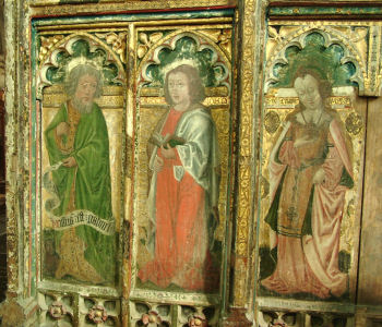
In 1701 Thomas Neale’s will instructed his widow to erect a Town House within a year of her death if not built in her lifetime, for four Persons or Families that everyone of the said Persons might have a Room or other fitting & reasonable Conveniences, & if not enough of this Description, married Couples too old to have Children born there or any young Children living with them. She also left in her will the wherewithal to maintain the almshouses. Thomas Neale’s will also left to the Churchwardens of Bramfield for ever yearly the sum of Three Pounds to be employed towards paying one of the Persons residing in the Almshouses, if one capable can be found to live there, to teach six Poor Children to read the Bible; and also the Testator that the Children so taught shall be of such Parents who didst whilst living take constant Alms or Relief of the Parish... Also further leaves to the Churchwarden of Bramfield the yearly sum of TEN SHILLINGS for ever, to buy Bibles, or other Religious Books. A further bequest from a Mrs Fowles in 1723 leaves money to the Churchwardens £80 for the purchase of land the rents from it to be used for teaching of Poor Children to read & give each a Bible when they can read it.
 The Almshouses were built in 1723 and some teaching started with Thomas Edwards as the teacher but quickly
succeeded by Good Steel. Was Thomas Edwards not "suitable" and quickly succeeded by Good Steel ?
A regular place for teaching was not built until 1803. A memorandum in the Churchwarden’s Disbursements for
20th June 1802 state that a School Room for the use of the said Parish shall be built at the North end of the Almshouses. This room continued in use until 1872 when the present school building was opened.
The Almshouses were built in 1723 and some teaching started with Thomas Edwards as the teacher but quickly
succeeded by Good Steel. Was Thomas Edwards not "suitable" and quickly succeeded by Good Steel ?
A regular place for teaching was not built until 1803. A memorandum in the Churchwarden’s Disbursements for
20th June 1802 state that a School Room for the use of the said Parish shall be built at the North end of the Almshouses. This room continued in use until 1872 when the present school building was opened.
The almshouses and schoolhouse were demolished in 1968.
As an interesting sidelight on education in Bramfield, is an attempt made in 1938 by the vicar, the Rev. Cyril Barker to found a Grammar School in the Vicarage. A very elaborate prospectus was published with extravagant aims of Academic Scholarships, a Cadet Corps, games, athletics and all manner of subjects not found taught in schools in the locality. It is described as a "Private Day School for boys 10 years and upwards" at a cost of 5 guineas a term. This was in answer to the feud the Rev. Barker had with the newly appointed Head Teacher of the Village School, Miss Smy. When the Rev. Barker arrived in 1937 he assumed that he would be invited to attend the school every day for morning assembly and generally oversee the religious life of the school. Miss Smy was not happy with this and forbade him from visiting the school. In the end the Rev Barker had to apologise to the Head Teacher in the press. As a final blow, his "Grammar School" only lasted a matter of weeks and was closed by the education authorities as the whole thing was so irregular.
Although the Rev Barker seems to be remembered fondly by the people who were children during his brief incumbency, going about on his bicycle with his kettle on the back seeking the best well water, he does seem to have caused an inordinate amount of trouble in the parish, taking the Church Council to the High Court in 1939 over a dispute about 12s.1½d missing from a cash box in the church. The box had contained the money for the Deanery magazine plus some church collections and the vicar had used the whole amount to pay for the magazines. The churchwardens accused the vicar of stealing the church money and told him to leave. He took them to court, suing for libel. Having heard the facts laid out by the prosecution the judge remarked that the people of Bramfield were very touchy people! The defence counsel for the churchwardens was Quentin Hogg (later Lord Hailsham and Lord Chancellor), at the time a brilliant young lawyer, who quickly demolished the character of the Rev Barker and he lost the case. He left the parish soon after.
Bramfield United Reform Church
Bramfield Chapel was built in 1842 and belongs to the Halesworth Independent Denomination. The building of it
came about because the Haward family of North Manor Farm were already members of the Halesworth church
and as Mrs Haward became aged it was thought that it would be a good idea to have a chapel in the village. Her
husband, Robert Haward gave 20 roods of land right opposite the farm to build the chapel. He also gave land up
the hill towards Halesworth for a Primitive Methodist Chapel to be built. It was always understood that this
chapel, changed into a house in the 1980’s should not hold services at the same time as the Chapel at the foot of
the hill.
Regular services are held at the URC every 2nd Sunday at 3pm. Paul and Pat Potts 01986 784 504.
Maltings Terrace
The first mention of malting in Bramfield that I have found is with the name of ‘Thomas Rous, maltster’ buried April 28 1697. The malting may have taken place in the vicinity of the present buildings but the present buildings are 18th century in date. The malting apparently went on until the beginning of the 20th century when they were turned into 6 dwellings. The last maltster in Whites Directory is listed as W. Higham in 1904. The malt would have been taken to Southwold for shipping or to Halesworth for brewing. Some was used locally for brewing. The growth of the malting and brewing industry in Halesworth during the first part of the 19th century and eventually the arrival of the railway meant that small-scale operations in villages came to an end.
Farming
The principal changes are the loss of the dairy herds at Broad Oak Farm and Brights Farm which have been replaced with suckler herds. Brights Farm is trading as organic now and the beef can be found at The Queen’s Head Pub; they also do Bed and Breakfast. North Manor Farm is now an Equestrian Centre and the house does Bed and Breakfast. Earlsway Farm, an arable farm, also trains dressage horses. Valley Farm is a riding establishment. The house at Grove Farm is a self catering large let but the land is still farmed by a tenant. Brook Hall Farm, Westley Farm and Hill Farm are entirely arable. The last fruit farm Holly Farm gave up apples in 2000 and is now arable with some grazing.
 Milling
The first mention of milling is in 1296 when Simon the Marshal was granted a licence for a water mill at the bridge by North Manor Farm on the A144. This does not necessarily mean that a mill was erected. From manorial documents it is known that there were medieval windmills at the top of Walpole Road just over the bridge and on Shorts Farm land. The last mills were Bramfield Mill at the top of Thorington Road and Waterloo Mill just before the railway crossing on the A144. They were dismantled in 1904 and 1944 respectively.
Development
Bramfield is a non-development village and so the only new houses are the six on the Alms House site and six, plus the units on Church Farm site. A small amount of in-fill housing has been built opposite the school. So generally Bramfield has not changed a great deal during the last forty years.
Footnote
This is not an exhaustive history and I am aware that there is probably much omitted. For instance Bramfield in the 19th Century was like all the other villages around Halesworth, a more or less self contained community with many more people, shopkeepers, tradesmen and facilities. This is a study on its own and there are plenty of printed sources available and perhaps one day someone will pick up the baton and run with it!
Bramfield.net is part of the Blythweb Group of Local Sites and is owned and operated by Blythweb which is
a trading name of MHCreations
(Formerly Blythweb Ltd 1999 - 2017).
and should not be used elsewhere without prior permission.